Sevenoaks Local Plan - Kemsing, Kent
Protect Kemsing - Act Now
The future of Kemsing is under threat.
The new Sevenoaks Local Plan proposes to include sites KEM1, KEM2, KEM3, KEM4, KEM5, and NOA1
for development - adding around 400 new homes in and around our village.
This would increase housing in Kemsing by over 30%, forever changing the peaceful, rural character of our
historic community.
A plan that doesn't fit our village
This level of development is completely out of proportion to Kemsing's size and infrastructure.
Our roads, schools, healthcare and public transport are already under pressure - yet this plan would add hundreds more cars and residents.
The nearby Bat and Ball Quarry development will already bring heavy traffic to the same narrow routes - Childsbridge Lane and Pilgrims Way - worsening congestion and pollution.
Together, these developments would push our village to breaking point.
Failing National Planning Tests
According to the National Planning Policy Framework (NPPF) and the Government's Grey Belt criteria, development must:
-
Provide clear community benefits
-
Improve the environment
-
Avoid urban sprawl
-
Protect heritage and biodiversity
None of these proposed sites meet those standards.
Instead, they would damage our countryside, threaten wildlife and destroy the very character that makes Kemsing a wonderful place to live.
What You Can Do
Now is the time to speak up.
Once these sites are approved, the damage will be permanent.
We need as many residents as possible to submit EVIDENCE BASED objections and make it clear that Kemsing says NO to unsustainable, unnecessary development.
Please don't copy and paste - it's imperative this is in your own words and using your voice, keeping it factual and based on how it impacts your daily life.
Have your say today - before it's too late.
How to Object
Video Guide
Click here to start your submission
Reasons to Object
OBJECTION TO THE SEVENOAKS LOCAL PLAN –
PROPOSED DEVELOPMENT IN KEMSING
(Sites KEM1–KEM5 and NOA1)
Site-by-Site Objections
1. KEM1 – 5 proposed new houses - Land West of Park Lane
-
Road Infrastructure & Traffic:
Kemsing is uniquely placed with its rural road infrastructure; there are only three viable entry and egress points. Each with their own issues.
1 - Pilgrims Way East - narrow, busy route which is single track at points and cannot accommodate HGV access. No pedestrian footpath. Highly used for commuting, school routes, backing up with long queues at busy points. The road is currently inadequate for the volume of traffic and poses safety concerns.
A pedestrian was struck by a vehicle and sadly killed whilst walking her dog along Pilgrims Way East in October 2015.
2 - Childsbridge Lane - already congested, serving as a diversion route whenever Pilgrims Way East closes. A narrow exit at Seal on to a very busy A25. Flooding issues. It's a major route at all times, that currently can't cope at peak times, and this will be exacerbated further by the completion of the quarry development site of 900 new homes which will further overload this road.
The road is heavily used by school children walking and cycling to secondary school at the Sevenoaks Education Campus (Trinity, Tech & Weald schools), this presents obvious road safety concerns for children and their parents.
There is also a railway bridge which narrows the road and has no pedestrian footpath.
3 - Noah's Ark - narrow roads, already congested with little-to-no off-road parking. Leads out to either Watery Lane which is prone to flooding or by country lanes back to the Childsbridge Lane exit at Seal High Street.
It is predicted that Seal Road and Seal Hollow Road will worsen from Level Of Service E to F which is the worst category possible
These traffic problems, especially with the A25 congestion have already been highlighted in Sevenoaks District Council reports from 2023 and 2025.
Key points -
Journey time increasing
Road safety for children and parents
More traffic - more wear and tear on roads - more closures. Mention specific road closures and your experiences/ photos.
-
Highways and HGV Access Concerns
The proposed development relies on access via Pilgrims Way East and Childsbridge Lane, both of which are narrow rural and residential roads wholly unsuited to the volume and size of heavy goods vehicles required for large-scale construction.
Parish Council records confirm that at least one of these routes is officially marked “unsuitable for HGVs.” These lanes have restricted width, poor visibility, and limited passing places, creating serious safety risks for pedestrians, cyclists, and existing road users. Sustained HGV use would cause significant noise, vibration, congestion, and damage to road surfaces, severely affecting residential amenity. Any necessary road widening or strengthening to facilitate HGV access would be disproportionate and environmentally harmful within this sensitive setting.
-
Biodiversity & Wildlife:
If you have seen any of the below species in this site please document and use this in your objection, photos are great!
- Bats
- Great crested newt
- Dormouse
- Reptiles - Lizards & Snakes
- Badgers
- Breeding & ground nesting birds
-
Water & Sewage:
The existing foul-water system is already at capacity; additional homes would cause sewage surcharges and risk contamination of local watercourses. No demonstrable assurance exists that the sewage infrastructure can handle the proposed large-scale development.
-
Transport & Parking:
Public transport access is poor. Parking at both Kemsing and Otford stations is already over capacity, with cars spilling onto nearby residential roads. This site will make parking and congestion worse without viable alternatives.
-
Local Services (GPs, Dentists, Schools, Emergency Services):
GP practices and dentists serving Kemsing and Otford already face long waits and limited lists; additional residents would exacerbate access problems. Primary and secondary school places are constrained; without funded, deliverable expansion before occupation, this proposal will overload education provision. Increased congestion further delays ambulances and fire services on narrow lanes.
-
Chalk Streams
All around Kemsing are Chalk streams - which are fragile, protected ecosystems - which are set to become legally protected as the bill has been passed through the House of Lords.
-
Air Pollution
Air pollution levels could rise as a result of additional traffic, especially given that Kemsing is at the base of the North Downs - an area of natural beauty that might be affected by degraded air quality, harming both residents' health and the local environment.
-
Heritage/History
Proposed developments threaten to damage Kemsing's historic and rural character. They risk harming listed buildings, disrupting the Conservation Area, and disturbing archaeological sites linked to the village’s Roman and medieval past. The developments would also impact the Kent Downs Natural Landscape (AONB), spoiling traditional views and diminishing Kemsing’s long-standing agricultural heritage. Overall, such changes could erode the village’s historic identity and transform its rural landscape into a more urban environment.
2. KEM2 -7 proposed new homes Land South of West End
-
Road Infrastructure & Traffic:
Kemsing is uniquely placed with its rural road infrastructure; there are only three viable entry and egress points. Each with their own issues.
1 - The likely proposed entrance into KEM2 is on a dangerous blind bend along West End and opposite an already busy junction West End / Copperfields. Thus posing a safety issue.
2 - Pilgrims Way East - narrow, busy route which is single track at points and cannot accommodate HGV access. No pedestrian footpath. Highly used for commuting, school routes, backing up with long queues at busy points. The road is currently inadequate for the volume of traffic and poses safety concerns.
A pedestrian was struck by a vehicle and sadly killed whilst walking her dog along Pilgrims Way East in October 2015.
3 - Childsbridge Lane - already congested, serving as a diversion route whenever Pilgrims Way East closes. A narrow exit at Seal on to a very busy A25. Flooding issues. It's a major route at all times, that currently can't cope at peak times, and this will be exacerbated further by the completion of the quarry development site of 900 new homes which will further overload this road.
The road is heavily used by school children walking and cycling to secondary school at the Sevenoaks Education Campus (Trinity, Tech & Weald schools), this presents obvious road safety concerns for children and their parents.
There is also a railway bridge which narrows the road and has no pedestrian footpath.
4 - Noah's Ark - narrow roads, already congested with little-to-no off-road parking. Leads out to either Watery Lane which is prone to flooding or by country lanes back to the Childsbridge Lane exit at Seal High Street.
It is predicted that Seal Road and Seal Hollow Road will worsen from Level Of Service E to F which is the worst category possible
These traffic problems, especially with the A25 congestion have already been highlighted in Sevenoaks District Council reports from 2023 and 2025.
Key points -
Journey time increasing
Road safety for children and parents
More traffic - more wear and tear on roads - more closures. Mention specific road closures and your experiences/ photos.
-
Highways and HGV Access Concerns
The proposed development relies on access via Pilgrims Way East and Childsbridge Lane, both of which are narrow rural and residential roads wholly unsuited to the volume and size of heavy goods vehicles required for large-scale construction.
Parish Council records confirm that at least one of these routes is officially marked “unsuitable for HGVs.” These lanes have restricted width, poor visibility, and limited passing places, creating serious safety risks for pedestrians, cyclists, and existing road users. Sustained HGV use would cause significant noise, vibration, congestion, and damage to road surfaces, severely affecting residential amenity. Any necessary road widening or strengthening to facilitate HGV access would be disproportionate and environmentally harmful within this sensitive setting.
-
Biodiversity & Wildlife:
If you have seen any of the below species in this site please document and use this in your objection, photos are great!
- Bats
- Great crested newt
- Dormouse
- Reptiles - Lizards & Snakes
- Badgers
- Breeding & ground nesting birds
-
Water & Sewage:
The existing foul-water system is already at capacity; additional homes would cause sewage surcharges and risk contamination of local watercourses. No demonstrable assurance exists that the sewage infrastructure can handle the proposed large-scale development.
-
Transport & Parking:
Public transport access is poor. Parking at both Kemsing and Otford stations is already over capacity, with cars spilling onto nearby residential roads. This site will make parking and congestion worse without viable alternatives.
-
Local Services (GPs, Dentists, Schools, Emergency Services):
GP practices and dentists serving Kemsing and Otford already face long waits and limited lists; additional residents would exacerbate access problems. Primary and secondary school places are constrained; without funded, deliverable expansion before occupation, this proposal will overload education provision. Increased congestion further delays ambulances and fire services on narrow lanes.
-
Chalk Streams
All around Kemsing are Chalk streams - which are fragile, protected ecosystems - which are set to become legally protected as the bill has been passed through the House of Lords. This site has a Chalk streams that neighbours it.
-
Air Pollution
Air pollution levels could rise as a result of additional traffic, especially given that Kemsing is at the base of the North Downs - an area of natural beauty that might be affected by degraded air quality, harming both residents' health and the local environment.
-
Proximity to other Kemsing sites in the Sevenoaks Plan
KEM2 is situated adjacent to both KEM3 and KEM5; representing an enormous increase in the built environment in one immediate location.
-
Heritage/History
Proposed developments threaten to damage Kemsing's historic and rural character. They risk harming listed buildings, disrupting the Conservation Area, and disturbing archaeological sites linked to the village’s Roman and medieval past. The developments would also impact the Kent Downs Natural Landscape (AONB), spoiling traditional views and diminishing Kemsing’s long-standing agricultural heritage. Overall, such changes could erode the village’s historic identity and transform its rural landscape into a more urban environment.
3. KEM3 – 20 proposed new homes Childsbridge Lane KEM3
-
Road Infrastructure & Traffic:
Kemsing is uniquely placed with its rural road infrastructure; there are only three viable entry and egress points. Each with their own issues.
1 - Pilgrims Way East - narrow, busy route which is single track at points and cannot accommodate HGV access. No pedestrian footpath. Highly used for commuting, school routes, backing up with long queues at busy points. The road is currently inadequate for the volume of traffic and poses safety concerns.
A pedestrian was struck by a vehicle and sadly killed whilst walking her dog along Pilgrims Way East in October 2015.
2 - Childsbridge Lane - already congested, serving as a diversion route whenever Pilgrims Way East closes. A narrow exit at Seal on to a very busy A25. Flooding issues. It's a major route at all times, that currently can't cope at peak times, and this will be exacerbated further by the completion of the quarry development site of 900 new homes which will further overload this road.
The road is heavily used by school children walking and cycling to secondary school at the Sevenoaks Education Campus (Trinity, Tech & Weald schools), this presents obvious road safety concerns for children and their parents.
There is also a railway bridge which narrows the road and has no pedestrian footpath.
3 - Noah's Ark - narrow roads, already congested with little-to-no off-road parking. Leads out to either Watery Lane which is prone to flooding or by country lanes back to the Childsbridge Lane exit at Seal High Street.
It is predicted that Seal Road and Seal Hollow Road will worsen from Level Of Service E to F which is the worst category possible
These traffic problems, especially with the A25 congestion have already been highlighted in Sevenoaks District Council reports from 2023 and 2025.
Key points -
Journey time increasing
Road safety for children and parents
More traffic - more wear and tear on roads - more closures. Mention specific road closures and your experiences/ photos.
-
Highways and HGV Access Concerns
The proposed development relies on access via Pilgrims Way East and Childsbridge Lane, both of which are narrow rural and residential roads wholly unsuited to the volume and size of heavy goods vehicles required for large-scale construction.
Parish Council records confirm that at least one of these routes is officially marked “unsuitable for HGVs.” These lanes have restricted width, poor visibility, and limited passing places, creating serious safety risks for pedestrians, cyclists, and existing road users. Sustained HGV use would cause significant noise, vibration, congestion, and damage to road surfaces, severely affecting residential amenity. Any necessary road widening or strengthening to facilitate HGV access would be disproportionate and environmentally harmful within this sensitive setting.
-
Biodiversity & Wildlife:
If you have seen any of the below species in this site please document and use this in your objection, photos are great!
- Bats
- Great crested newt
- Dormouse
- Reptiles - Lizards & Snakes
- Badgers
- Breeding & ground nesting birds
-
Water & Sewage:
The existing foul-water system is already at capacity; additional homes would cause sewage surcharges and risk contamination of local watercourses. No demonstrable assurance exists that the sewage infrastructure can handle the proposed large-scale development.
-
Transport & Parking:
Public transport access is poor. Parking at both Kemsing and Otford stations is already over capacity, with cars spilling onto nearby residential roads. This site will make parking and congestion worse without viable alternatives.
-
Local Services (GPs, Dentists, Schools, Emergency Services):
GP practices and dentists serving Kemsing and Otford already face long waits and limited lists; additional residents would exacerbate access problems. Primary and secondary school places are constrained; without funded, deliverable expansion before occupation, this proposal will overload education provision. Increased congestion further delays ambulances and fire services on narrow lanes.
-
Chalk Streams
All around Kemsing are Chalk streams - which are fragile, protected ecosystems - which are set to become legally protected as the bill has been passed through the House of Lords. This site has a Chalk streams that neighbours it.
-
Air Pollution
Air pollution levels could rise as a result of additional traffic, especially given that Kemsing is at the base of the North Downs - an area of natural beauty that might be affected by degraded air quality, harming both residents' health and the local environment.
-
Proximity to other Kemsing sites in the Sevenoaks Plan
KEM3 is situated adjacent to both KEM2 and KEM5; representing an enormous increase in the built environment in one immediate location.
-
Heritage/History
Proposed developments threaten to damage Kemsing's historic and rural character. They risk harming listed buildings, disrupting the Conservation Area, and disturbing archaeological sites linked to the village’s Roman and medieval past. The developments would also impact the Kent Downs Natural Landscape (AONB), spoiling traditional views and diminishing Kemsing’s long-standing agricultural heritage. Overall, such changes could erode the village’s historic identity and transform its rural landscape into a more urban environment.
4. KEM4 – 120 proposed new homes Land West of Childsbridge Lane
-
Road Infrastructure & Traffic:
Kemsing is uniquely placed with its rural road infrastructure; there are only three viable entry and egress points. Each with their own issues.
1 - Pilgrims Way East - narrow, busy route which is single track at points and cannot accommodate HGV access. No pedestrian footpath. Highly used for commuting, school routes, backing up with long queues at busy points. The road is currently inadequate for the volume of traffic and poses safety concerns.
A pedestrian was struck by a vehicle and sadly killed whilst walking her dog along Pilgrims Way East in October 2015.
2 - Childsbridge Lane - already congested, serving as a diversion route whenever Pilgrims Way East closes. A narrow exit at Seal on to a very busy A25. Flooding issues. It's a major route at all times, that currently can't cope at peak times, and this will be exacerbated further by the completion of the quarry development site of 900 new homes which will further overload this road.
The road is heavily used by school children walking and cycling to secondary school at the Sevenoaks Education Campus (Trinity, Tech & Weald schools), this presents obvious road safety concerns for children and their parents.
There is also a railway bridge which narrows the road and has no pedestrian footpath.
3 - Noah's Ark - narrow roads, already congested with little-to-no off-road parking. Leads out to either Watery Lane which is prone to flooding or by country lanes back to the Childsbridge Lane exit at Seal High Street.
It is predicted that Seal Road and Seal Hollow Road will worsen from Level Of Service E to F which is the worst category possible
These traffic problems, especially with the A25 congestion have already been highlighted in Sevenoaks District Council reports from 2023 and 2025.
Key points -
Journey time increasing
Road safety for children and parents
More traffic - more wear and tear on roads - more closures. Mention specific road closures and your experiences/ photos.
-
Highways and HGV Access Concerns
The proposed development relies on access via Pilgrims Way East and Childsbridge Lane, both of which are narrow rural and residential roads wholly unsuited to the volume and size of heavy goods vehicles required for large-scale construction.
Parish Council records confirm that at least one of these routes is officially marked “unsuitable for HGVs.” These lanes have restricted width, poor visibility, and limited passing places, creating serious safety risks for pedestrians, cyclists, and existing road users. Sustained HGV use would cause significant noise, vibration, congestion, and damage to road surfaces, severely affecting residential amenity. Any necessary road widening or strengthening to facilitate HGV access would be disproportionate and environmentally harmful within this sensitive setting.
-
Biodiversity & Wildlife:
If you have seen any of the below species in this site please document and use this in your objection, photos are great!
- Bats
- Great crested newt
- Dormouse
- Reptiles - Lizards & Snakes
- Badgers
- Breeding & ground nesting birds
-
Water & Sewage:
The existing foul-water system is already at capacity; additional homes would cause sewage surcharges and risk contamination of local watercourses. No demonstrable assurance exists that the sewage infrastructure can handle the proposed large-scale development.
-
Transport & Parking:
Public transport access is poor. Parking at both Kemsing and Otford stations is already over capacity, with cars spilling onto nearby residential roads. This site will make parking and congestion worse without viable alternatives.
-
Local Services (GPs, Dentists, Schools, Emergency Services):
GP practices and dentists serving Kemsing and Otford already face long waits and limited lists; additional residents would exacerbate access problems. Primary and secondary school places are constrained; without funded, deliverable expansion before occupation, this proposal will overload education provision. Increased congestion further delays ambulances and fire services on narrow lanes.
-
Chalk Streams
All around Kemsing are Chalk streams - which are fragile, protected ecosystems - which are set to become legally protected as the bill has been passed through the House of Lords. This site has a Chalk streams that runs right through it.
-
Air Pollution
Air pollution levels could rise as a result of additional traffic, especially given that Kemsing is at the base of the North Downs - an area of natural beauty that might be affected by degraded air quality, harming both residents' health and the local environment.
-
Proximity to other Kemsing sites in the Sevenoaks Plan
KEM4 is situated adjacent to both KEM3; representing an enormous increase in the built environment in one immediate location.
-
Flood risk
The KEM4 site is a flood plain which is there to protect the immediately adjacent M26 motorway.
-
TPOs (Tree Preservation Orders)
There are trees on this site with TPOs against them and developments and construction could potentially damage and harm these protected trees.
-
"Village to village" development
"A type of development that can be considered on grey belt land, where the focus is on developing land situated between existing villages. It differs from urban sprawl in that it aims to infill between established settlements rather than create a continuous urbanised area."
Seal is effectively already an extension of the town (Sevenoaks) linked by the houses along the A25. Adjoining Kemsing with Seal surely ‘is’ creating urban sprawl. The M26 alone cannot be classed as separation border between the two.
-
Heritage/History
Proposed developments threaten to damage Kemsing's historic and rural character. They risk harming listed buildings, disrupting the Conservation Area, and disturbing archaeological sites linked to the village’s Roman and medieval past. The developments would also impact the Kent Downs Natural Landscape (AONB), spoiling traditional views and diminishing Kemsing’s long-standing agricultural heritage. Overall, such changes could erode the village’s historic identity and transform its rural landscape into a more urban environment.
5. KEM5 – 181 proposed new homes Field West End KEM5
-
Road Infrastructure & Traffic:
Kemsing is uniquely placed with its rural road infrastructure; there are only three viable entry and egress points. Each with their own issues.
1 - Pilgrims Way East - narrow, busy route which is single track at points and cannot accommodate HGV access. No pedestrian footpath. Highly used for commuting, school routes, backing up with long queues at busy points. The road is currently inadequate for the volume of traffic and poses safety concerns.
A pedestrian was struck by a vehicle and sadly killed whilst walking her dog along Pilgrims Way East in October 2015.
The entrance to the proposed site is likely to be on West End.
2 - Childsbridge Lane - already congested, serving as a diversion route whenever Pilgrims Way East closes. A narrow exit at Seal on to a very busy A25. Flooding issues. It's a major route at all times, that currently can't cope at peak times, and this will be exacerbated further by the completion of the quarry development site of 900 new homes which will further overload this road.
The road is heavily used by school children walking and cycling to secondary school at the Sevenoaks Education Campus (Trinity, Tech & Weald schools), this presents obvious road safety concerns for children and their parents.
There is also a railway bridge which narrows the road and has no pedestrian footpath.
3 - Noah's Ark - narrow roads, already congested with little-to-no off-road parking. Leads out to either Watery Lane which is prone to flooding or by country lanes back to the Childsbridge Lane exit at Seal High Street.
It is predicted that Seal Road and Seal Hollow Road will worsen from Level Of Service E to F which is the worst category possible
These traffic problems, especially with the A25 congestion have already been highlighted in Sevenoaks District Council reports from 2023 and 2025.
Key points -
Journey time increasing
Road safety for children and parents
More traffic - more wear and tear on roads - more closures. Mention specific road closures and your experiences/ photos.
-
Highways and HGV Access Concerns
The proposed development relies on access via Pilgrims Way East and Childsbridge Lane, both of which are narrow rural and residential roads wholly unsuited to the volume and size of heavy goods vehicles required for large-scale construction.
Parish Council records confirm that at least one of these routes is officially marked “unsuitable for HGVs.” These lanes have restricted width, poor visibility, and limited passing places, creating serious safety risks for pedestrians, cyclists, and existing road users. Sustained HGV use would cause significant noise, vibration, congestion, and damage to road surfaces, severely affecting residential amenity. Any necessary road widening or strengthening to facilitate HGV access would be disproportionate and environmentally harmful within this sensitive setting.
-
Biodiversity & Wildlife:
If you have seen any of the below species in this site please document and use this in your objection, photos are great!
- Bats
- Great crested newt
- Dormouse
- Reptiles - Lizards & Snakes
- Badgers
- Breeding & ground nesting birds
-
Water & Sewage:
The existing foul-water system is already at capacity; additional homes would cause sewage surcharges and risk contamination of local watercourses. No demonstrable assurance exists that the sewage infrastructure can handle the proposed large-scale development.
-
Transport & Parking:
Public transport access is poor. Parking at both Kemsing and Otford stations is already over capacity, with cars spilling onto nearby residential roads. This site will make parking and congestion worse without viable alternatives.
-
Local Services (GPs, Dentists, Schools, Emergency Services):
GP practices and dentists serving Kemsing and Otford already face long waits and limited lists; additional residents would exacerbate access problems. Primary and secondary school places are constrained; without funded, deliverable expansion before occupation, this proposal will overload education provision. Increased congestion further delays ambulances and fire services on narrow lanes.
-
Chalk Streams
All around Kemsing are Chalk streams - which are fragile, protected ecosystems - which are set to become legally protected as the bill has been passed through the House of Lords. This site has a Chalk streams that neighbours it if not runs through it.
-
Air Pollution
Air pollution levels could rise as a result of additional traffic, especially given that Kemsing is at the base of the North Downs - an area of natural beauty that might be affected by degraded air quality, harming both residents' health and the local environment.
-
Proximity to other Kemsing sites in the Sevenoaks Plan
KEM5 is situated adjacent to both KEM3 and KEM2; representing an enormous increase in the built environment in one immediate location.
-
National Landscape (aka Area of Outstanding Natural Beauty)
The proposed site can be viewed directly from Kemsing Down (above the village); damaging the view from that key, protected vantage point.
-
Conservation area and Listed buildings
The KEM5 site is in close proximity to the Kemsing Conservation area (centre of the oldest part of the village) as well as being situated very close to a number of listed buildings. The Conservation documentation marks it as contributing to the area.
-
TPOs (Tree Preservation Orders) and Ancient Woodland
There are both trees on this site with TPOs against them and Ancient Woodland. Developments and construction could potentially damage and harm these protected trees.
-
"Village to village" development
"A type of development that can be considered on grey belt land, where the focus is on developing land situated between existing villages. It differs from urban sprawl in that it aims to infill between established settlements rather than create a continuous urbanised area."
Seal is effectively already an extension of the town (Sevenoaks) linked by the houses along the A25. Adjoining Kemsing with Seal surely ‘is’ creating urban sprawl. The M26 alone cannot be classed as separation border between the two.
-
Heritage/History
Proposed developments threaten to damage Kemsing's historic and rural character. They risk harming listed buildings, disrupting the Conservation Area, and disturbing archaeological sites linked to the village’s Roman and medieval past. The developments would also impact the Kent Downs Natural Landscape (AONB), spoiling traditional views and diminishing Kemsing’s long-standing agricultural heritage. Overall, such changes could erode the village’s historic identity and transform its rural landscape into a more urban environment.
6. NOA1 – 40 Around Noah’s Ark
-
Road Infrastructure & Traffic:
Kemsing is uniquely placed with its rural road infrastructure; there are only three viable entry and egress points. Each with their own issues.
1 - Pilgrims Way East - narrow, busy route which is single track at points and cannot accommodate HGV access. No pedestrian footpath. Highly used for commuting, school routes, backing up with long queues at busy points. The road is currently inadequate for the volume of traffic and poses safety concerns.
A pedestrian was struck by a vehicle and sadly killed whilst walking her dog along Pilgrims Way East in October 2015.
2 - Childsbridge Lane - already congested, serving as a diversion route whenever Pilgrims Way East closes. A narrow exit at Seal on to a very busy A25. Flooding issues. It's a major route at all times, that currently can't cope at peak times, and this will be exacerbated further by the completion of the quarry development site of 900 new homes which will further overload this road.
The road is heavily used by school children walking and cycling to secondary school at the Sevenoaks Education Campus (Trinity, Tech & Weald schools), this presents obvious road safety concerns for children and their parents.
There is also a railway bridge which narrows the road and has no pedestrian footpath.
3 - Noah's Ark - narrow roads, already congested with little-to-no off-road parking. Leads out to either Watery Lane which is prone to flooding or by country lanes back to the Childsbridge Lane exit at Seal High Street.
It is predicted that Seal Road and Seal Hollow Road will worsen from Level Of Service E to F which is the worst category possible
These traffic problems, especially with the A25 congestion have already been highlighted in Sevenoaks District Council reports from 2023 and 2025.
Key points -
Journey time increasing
Road safety for children and parents
More traffic - more wear and tear on roads - more closures. Mention specific road closures and your experiences/ photos.
-
Highways and HGV Access Concerns
The proposed development relies on access via Pilgrims Way East and Childsbridge Lane, both of which are narrow rural and residential roads wholly unsuited to the volume and size of heavy goods vehicles required for large-scale construction.
Parish Council records confirm that at least one of these routes is officially marked “unsuitable for HGVs.” These lanes have restricted width, poor visibility, and limited passing places, creating serious safety risks for pedestrians, cyclists, and existing road users. Sustained HGV use would cause significant noise, vibration, congestion, and damage to road surfaces, severely affecting residential amenity. Any necessary road widening or strengthening to facilitate HGV access would be disproportionate and environmentally harmful within this sensitive setting.
-
Biodiversity & Wildlife:
If you have seen any of the below species in this site please document and use this in your objection, photos are great!
- Bats
- Great crested newt
- Dormouse
- Reptiles - Lizards & Snakes
- Badgers
- Breeding & ground nesting birds
-
Water & Sewage:
The existing foul-water system is already at capacity; additional homes would cause sewage surcharges and risk contamination of local watercourses. No demonstrable assurance exists that the sewage infrastructure can handle the proposed large-scale development.
-
Transport & Parking:
Public transport access is poor. Parking at both Kemsing and Otford stations is already over capacity, with cars spilling onto nearby residential roads. This site will make parking and congestion worse without viable alternatives.
-
Local Services (GPs, Dentists, Schools, Emergency Services):
GP practices and dentists serving Kemsing and Otford already face long waits and limited lists; additional residents would exacerbate access problems. Primary and secondary school places are constrained; without funded, deliverable expansion before occupation, this proposal will overload education provision. Increased congestion further delays ambulances and fire services on narrow lanes.
-
Chalk Streams
All around Kemsing are Chalk streams - which are fragile, protected ecosystems - which are set to become legally protected as the bill has been passed through the House of Lords. This site has a Chalk streams that neighbours it.
-
Air Pollution
Air pollution levels could rise as a result of additional traffic, especially given that Kemsing is at the base of the North Downs - an area of natural beauty that might be affected by degraded air quality, harming both residents' health and the local environment.
-
Flood risk
The area is susceptible to flood risk (as demonstrated in responses to a current, separate planning application in respect of Noah's Ark).
-
TPOs (Tree Preservation Orders) and Ancient Woodland
There are both trees near this site with TPOs against them and Ancient Woodland. Developments and construction could potentially damage and harm these protected trees.
-
Heritage/History
Proposed developments threaten to damage Kemsing's historic and rural character. They risk harming listed buildings, disrupting the Conservation Area, and disturbing archaeological sites linked to the village’s Roman and medieval past. The developments would also impact the Kent Downs Natural Landscape (AONB), spoiling traditional views and diminishing Kemsing’s long-standing agricultural heritage. Overall, such changes could erode the village’s historic identity and transform its rural landscape into a more urban environment.
3. Summary of Cumulative Impacts
The cumulative impact of these developments—totalling approximately 373 new homes—would place a disproportionate burden on Kemsing, increasing the village size by more than 30%. The effects include:
• Traffic & Safety: Severe congestion and danger on Pilgrims Way and Childsbridge Lane, especially during closures; slower emergency response times.
• Air Pollution: Already high NO₂ (≈ 37 µg/m³) and PM₂.₅ (≈ 20 µg/m³) levels will worsen from increased car dependency.
• Biodiversity: Habitat fragmentation threatens protected species (Bats, Great crested newt , Dormouse, Reptiles - Lizards & Snakes, Badgers, Breeding & ground nesting birds ) and undermines ecological networks.
• Tree Preservation Orders: Loss or weakening of TPO-protected trees harms landscape character and bat corridors.
• Water & Sewage: Overloaded drainage/foul systems increase flooding risk and threaten chalk-stream water quality.
• Transport & Parking: No viable public transport or station-parking solutions; overspill into residential streets.
• Local Services: No secured, funded expansion of GPs, dentists, schools or social care ahead of occupation; waiting times and travel distances would rise.
• Heritage & Landscape: Urban sprawl would merge Kemsing, Noah’s Ark, and Sevenoaks, erasing distinct historic identity and rural setting.
• Cumulative Development: The approved Bat and Ball Quarry scheme will compound these impacts, funnelling additional traffic through Kemsing’s narrow roads and accelerating urban sprawl by physically linking the village with Sevenoaks.
Conclusion
The proposed Kemsing sites KEM1–KEM5 and NOA1 would:
• Cause dangerous traffic and road safety impacts.
• Increase pollution from the M26 and new car journeys.
• Destroy wildlife habitats, protected trees, and chalk stream ecosystems.
• Overload local services (GPs, dentists, schools) and water/sewage infrastructure.
• Undermine heritage, character, and the Green Belt.
They are unsound, unsustainable, and contrary to both the NPPF and the Grey Belt framework.
Request:
That all Kemsing sites be removed from the Local Plan and that the Council prioritise:
• Genuine brownfield redevelopment,
• Protection of Tree Preservation Orders and chalk streams,
• Improvements to public transport and road safety
• Preservation of Kemsing’s rural heritage, biodiversity, and essential local services capacity.
Residents are encouraged to use this guide when submitting their own responses to the Sevenoaks Local Plan consultation.
Click here to start your submission
Information on Each Site
Thank you to those in Kemsing who have gathered & shared the below photos.
Site - KEM1
Photos - 2025
5 proposed new homes
Land West of Park Lane (KEM1)
Site - KEM2 -
Photos - 2025
7 proposed new homes
Land South of West End


Site - Kem 3 Photos - 2025
20 proposed new homes
Childsbridge Lane KEM3
Site - KEM4
Photos - 2025
120 proposed new homes
Land West of Childsbridge Lane
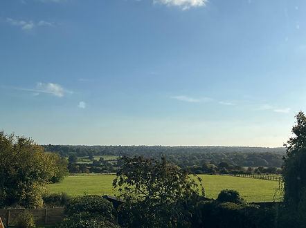
Site - KEM5 Photos - 2025
181 proposed new homes
Field West End
KEM5